We are “stuck” in a persistent NW flow pattern. What does that mean? Well, it’s a flow that comes in from Canada and typically gives us numerous chances for showers/storms. We will be in that pattern through early next week before summer heat FINALLY arrives as a big heat ridge builds in from the west. Take a look at one models projected highs for NEXT weekend (7-13)
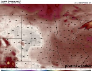
Highs across the state reaching into the 90s and a few 100s mixed in as well. This is great news for summer heat lovers as we shut the rain off and bring in the heat. So, if you like the “cooler” weather we have for the next 4-5 days enjoy that as a return to the 90s isn’t far away.
Chief Meteorologist,
Dean Wysocki