The next several days will hold chances and likely chances for scattered showers and storms, a few of those storms could be on the strong to severe side.
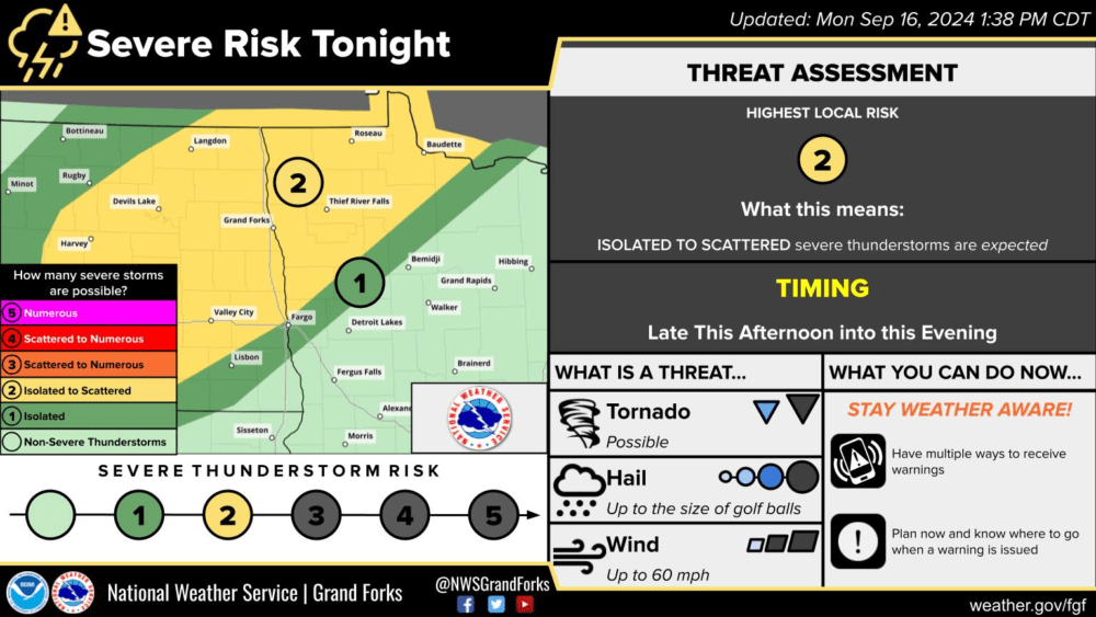
For Today Monday (9/16/24), a slight and marginal risk (level 2 yellow, and level 1 green, risk respectively) for severe weather has been issued for portions of Eastern North Dakota and Northwestern Minnesota. Through the afternoon, daytime heating will destabilize the atmosphere and bring the potential for thunderstorms to develop through the day into the evening. Storms will hold the potential for golf ball-sized hail, 60+ mph wind gusts, and even an isolated tornado.
Tonight a threat for strong storms continues but turns more into a wind threat with heavy rain due to possible entrainment. The greatest threat of storms will likely lift a bit further north, north of I94 and up to the Highway 2 corridor (and parts north) into Minnesota.
Tuesday and Wednesday (9/17-18): Both days will contain a chance for some showers or storms during the day and night. The best chances come late in the day Tuesday and overnight. A couple of storms again could be on the strong side.
Thursday (9/18): A cold front is expected to track across the Dakotas into Minnesota through the afternoon and evening. This front will likely develop a line or broken line of showers and storms. Depending on the timing of this front some storms could be on the strong to severe side with Minnesota holding the best chance for storms currently.
Rain chances look to diminish Friday and Saturday but more rain chances increase Sunday into the beginning of the following week.
Meteorolgist,
Justin Storm